La revue National Geographic explique dans ces vidéos le phénomène du tremblement de terre en termes simples, à la portée de tous.
Voici le lien unique qui conduit vers ces vidéos: Earthquakes.
Affichage des articles dont le libellé est séisme. Afficher tous les articles
Affichage des articles dont le libellé est séisme. Afficher tous les articles
samedi 12 mars 2011


jeudi 19 août 2010
Liquéfaction de certains dépôts de sol au cours d'un séisme
Préambule.-
Au cours d’un séisme, la vibration du sol peut entraîner une perte de résistance ou de rigidité des couches (fondation) de sol situées sous les ouvrages civils. Les conséquences immédiates sur ces ouvrages sont:
- Mouvement important des bâtiments (rotation, tassement, effondrement).
- Subsidence (affaissement généralisé sur une grande superficie) du sol.
- Glissement de terrain.
- Perte de stabilité de murs de soutènement.
- Rupture de pentes dans les ouvrages en terre.
- Liquéfaction du sol (peut être présente dans certains de cas ci-dessus.)
- et ainsi de suite.
La liquéfaction est donc l’un des processus par lesquels le sol de fondation conduit à des désordres. La liquéfaction est un phénomène associé principalement, mais pas exclusivement aux sols saturés sans cohésion. La liquéfaction du sol est observée dans la plupart des séismes importants.
Avant de fournir quelques notions plus techniques permettant de comprendre un peu le phénomène de liquéfaction, nous allons d'abord présenter un vidéo et quelques images dans le cas du séisme de Niigata, au Japon en 1964.
Mentionnons en passant que le phénomène de liquéfaction peut se manifester (et s'est manifesté le 12 janvier 2010) lors d'un séisme affectant certaines régions d'Haïti telles que: Léogâne, Port-au-Prince, le littoral entre Léogâne et Port-au-Prince, etc. Une étude sérieuse devrait être entreprise pour identifier avec plus de précision les zones où se situent les couches de sols liquéfiables en Haïti.
La liquéfaction du sol au cours du tremblement de terre de Niigata au Japon en 1964.-
Il s'agit du premier cas de liquéfaction retentissant dans le monde.
Nous avons trouvé sur le Web le vidéo ci-après sur la liquéfaction des sols réalisé au cours du séisme de Niigata, Japon en 1964:
- Copie 2 (son et image) / Niigata (1964)/Liquéfaction-2, sbrujic, 11 janvier 2010, 3 min, 55 sec.
- Copie 1 (image)/Niigata (1964)/Liquéfaction-1, dohdohtt, 12 août 2007, 3 min 55 sec
Les images qui suivent illustrent les dégâts causés par la liquéfaction durant le séisme de Niigata (1964).
Les dépôts de sols au vieux Niigata sont susceptibles de se liquéfier, tandis que ceux du nouveau Niigata ne le sont pas.
Figure 1.- Rotation de plusieurs blocs d'appartements dans le vieux Niigata au cours du séisme en 1964

Source: Winterkorn and Fang (1975)
Figure 2a.- Rotation d'un bloc d'appartements dans le Vieux Niigata au cours du séisme de 1964.

Source: Finn, Troisième conférence canadienne sur le Génie sismique, 1979, p. 96
Figure 2b.- Important bâtiment fondé sur pieux, situé dans le Vieux Niigata, mais non affecté par la liquéfaction au cours du séisme de 1964, ni dans sa structure, ni dans ses fondations.

Source: Finn, Troisième conférence canadienne sur le Génie sismique, 1979, p. 105
Figure 3a - Une vue d'avion du Nouveau Niigata immédiatement après le séisme de 1964 et non endommagé par le séisme.

Source: Finn, Troisième conférence canadienne sur le Génie sismique, 1979, p. 102
Figure 3b.- Une vue des dommages dans une rue du Vieux Niigata immédiatement après le séisme de 1964

Source: Finn, Troisième conférence canadienne sur le Génie sismique, 1979, p. 102
Figure 3c.- Relation entre l'âge géologique d'un dépôt de sable et sa densité (ou son indice des vides)

Source: Finn, Troisième conférence canadienne sur le Génie sismique, 1979, p. 103
Sur la figure 3c, on voit que plus le dépôt de sable est âgé, plus il est dense (masse volumique su sol sec élevée, indice des vides faible).
On a constaté que les alluvions de sable et les remblais hydraulique déposés depuis les travaux de restauration de Meiji à la fin du 19e siècle, se sont tous liquéfiés au cours du séisme de 1964 à Niigata. Les dépôts de sable plus âgés à Niigata ne se sont pas liquéfiés. Les figures 3a et 3b illustrent les deux situations à Niigata. La figure 3a montre le vieux Niigata après le séisme où aucun dommage n'est apparu. La figure 3b montre le nouveau Niigata où, pendant le séisme, le sol s'est liquéfié, et la rue est sous un mètre de sable liquéfié.
Il a été démontré que plus le dépôt d'alluvions est vieux, plus élevée est sa résistance à la liquéfaction. C'est ce qu'illustre la figure 3c qui provient d'une étude du chercheur japonais Tohono (Tohno (1975), cité par Finn dans les comptes rendus de la 3e conférence canadienne sur le génie parasismique). La figure 3c montre un accroissement dans la densité (ou une diminution dans l'indice des vides) des jeunes dépôts Holocène jusqu'aux très vieux dépôts de l'ère Tertiaire. Ces accroissements de densité peuvent se détecter par une augmentation des valeurs de l'indice de pénétration standards N. Nous reviendrons dans un autre article sur ce point.
Figure 4a.- Un bassin de traitement des eaux usées flottant sur sa fondation liquéfié au moment du séisme de Niigata (1964).

Source: Prakash (1979), Soil Dynamics
Figure 4b.- Une automobile se noie dans le sol liquéfié au cours du séisme de Niigata (1964)

Source: Prakash (1979), Soil Dynamics
La manifestation la plus courante de la liquéfaction durant le séisme.-
Le sable donne l’impression de bouillir en surface et un mélange de sable et d’eau sort en jets, tels des geysers ou des petits volcans en différents points de la surface.
Explication simplifié et rapide du phénomène.-
Les vibrations du sol lâche, saturé d’eau de la nappe phréatique, font que les particules solides ont tendance se rapprocher (tendance à la densification); alors l’eau du sol subit une augmentation de pression; cette pression interstitielle additionnelle repousse les grains solides jusqu’à défaire leurs contacts: alors le dépôt de sol en question «bout» et un mélange de grains et d’eau sort à la surface du dépôt en jets (comme un geyser).
Quelques considérations plus techniques:
Principe de Terzaghi: σ = σ’ + u
Loi de Coulomb (résistance au cisaillement): τf = (σ – u) tan φ’
Durant le séisme, σ reste constant, u augmente, donc σ’ peut diminuer jusqu’à s’annuler. Alors, la résitance (au cisaillement) du sol devient nulle.
Aperçu sur le cas d'Haïti: séisme du 12 janvier 2010.
Je n'ai pas encore eu la chance de visiter Haïti après le séisme. Je me fie donc aux témoignages de collègues ingénieurs civils, de chercheurs qui ont visité les lieux et qui ont collaboré à la rédaction de rapports techniques sur les dégâts causés par le séisme. Il faut noter que la liquéfaction est peu documentée et pas toujours convenablement expliquée. De plus, il y aurait des témoignages de gens (non spécialistes) qui étaient sur les lieux, par exemple, le phénomène de geyser (liquéfaction) à Léogane mentionné dans les nouvelles à la télé selon ce que m'avait rapporté un collège géotechnicien comme moi qui ne connaît Haïti que par des amis et les médias. Ces témoignages de profanes ont circulé sur le Web dans les jours qui ont suivi le séisme, mais nous n'avons pas pu les repérer sur la toile quelque six mois plus tard. Aussi, nous demandons au lecteur qui disposerait de photos prises au cours du séisme dans la zone côtière située entre la baie de Port-au-Prince et Petit-Goâve, incluant donc Martissant, la zone dite des Rails, Côte-Plage, Arcachon, Carrefour, Mariani, Gressier, Léogâne, Fauché, Grand-Goâve, etc, de bien vouloir communiquer ces images (photos numériques) au Coin de Pierre (jfjpm_2@yahoo.fr).
Dans le rapport: Analysis of Multiple Natural Hazards in Haiti, j'ai tiré les deux passages qui suivent:
«Liquefaction is sometimes also accompanied by deformation, and even by fracturing of upper soil layers, causing their displacement and lateral spread toward surrounding land depressions. Lastly, the soil’s loss of shear resistance also leads to a loss of its load-bearing capacity; buildings and other structures can therefore either sink, with differential settlements, or float owing to the buoyancy effect.»
«Liquefaction is significant particularly in river basins, alluvial depressions such as the Cul-de-Sac Plain, the deltas of the Froide river (Carrefour) and Momance river (Léogane), where the groundwater aquifer is close to the surface. Numerous examples of this type of effect were observed in the aftermath of the earthquake of January 12, 2010, particularly around port facilities in Port-au-Prince and fuel tanks at the Carrefour power plant, where damage was considerable.»
Nous reviendrons sur la liquéfaction dans un prochain article pour faire part de quelques solutions techniques disponibles pour contrer les effets de la liquéfaction voire l'éviter, si possible. On parlera aussi des techniques disponibles pour déceler si un dépôt est liquéfiable ou pas.
_______________________________
Références.-
- Comptes rendus Troisième conférence canadienne sur le génie parasismique, tomes 1 et 2, Montréal 4, 5 et 6 juin 1979, 1388 pages.
- Soil Dynamics, par Shamsher Prakash, Éditeur McGraw-Hill, 1981, 426 pages.
- Foundation Engineering Handbook, par Winterkorn, H.F. et Fang, H.Y., Éditeur Van Nostrand Reinold, 1975, 751 pages.
- Analysis of Multiple Natural Hazards in Haïti (NATHAT), 26 mars 2010, 63 pages.
À suivre.
Dr. Pierre Montès
Tous droits réservés, (c) 2010
Dernière mise à jour: 5 septembre 2010
dimanche 25 avril 2010
Haïti/Séisme 12 janvier 2010/Effondrement du Palais (vidéo)
Amies et amis internautes,
Voici un document vidéo sur l'effondrement du Palais national. Les images ont été captées par le système de surveillance-caméra du Palais.
Vous aurez aussi l'occasion d'entendre les principaux acteurs de la scène nationale.
Cliquez sur: Haïti/Séisme 12 janvier/Effondrement du Palais.
_________________________
Mise à jour du lundi 26 janvier 2010.-
Vous pouvez aussi cliquer sur : Patrick Lagacé/Jean-François Labadie.
mardi 9 mars 2010
Haïti-séisme/Rapport technique d'une équipe d'ingénieurs américains USGS/EERI, février 2010 (*)
THE MW 7.0 HAITI EARTHQUAKE OF JANUARY 12, 2010:
USGS/EERI Advance Reconnaissance Team: TEAM REPORT
V 1.1
V 1.1
February 23, 2010
EXECUTIVE SUMMARY
A field reconnaissance in Haiti by a five-member team with expertise in seismology and earthquake engineering has revealed a number of factors that led to catastrophic losses of life and property during the January 12, 2010, Mw 7.0 earthquake. The field study was conducted from January 26 to February 3, 2010, and included investigations in Port-au-Prince and the heavily damaged communities to the west, including Léogâne, Grand Goâve, Petite Goâve, and Oliver.
Seismology: Despite recent seismic quiescence, Haiti has suffered similar devastating earthquakes in the historic past (1701, 1751, 1770 and 1860). Haiti had no seismograph stations during the main earthquake, so it is impossible to estimate accurately the intensity of ground motions. Nonetheless, the wide range of buildings damaged by the January 12, 2010 earthquake suggests that the ground motions contained seismic energy over a wide range of frequencies. Another earthquake of similar magnitude could strike at any time on the eastern end of the Enriquillo Fault, directly to the south of Port-au-Prince. Reconstruction must take this hazard into account.
The four portable seismographs installed by the team recorded a series of small aftershocks. As expected, the ground motions recorded at a hard rock site contained a greater proportion of high frequencies than the motions recorded at a soil site. Two of the stations continue to monitor seismic activity.
A thorough field investigation led the team to conclude that this earthquake was unlikely to have produced any surface rupture.
Geotechnical Aspects: Soil liquefaction, landslides and rockslides in cut slopes, and road embankment failures contributed to extensive damage in Port-au-Prince and elsewhere. A lack of detailed knowledge of the physical conditions of the soils (e.g., lithology, stiffness, density, and thickness) made it difficult for us to quantitatively assess the role of ground-motion amplification in the widespread damage.
Buildings: The Haitian Ministry of Statistics and Infomatics reported that one-story buildings represent 73% of the building inventory. Most ordinary, one-story houses have roofs made of sheet metal (82%), whereas most multi-story houses and apartments have roofs made of concrete (71%). Walls made of concrete/block/stone predominate both in ordinary houses and apartments.
It appears that the widespread damage to residences, and commercial and government buildings was attributable to a great extent to the lack of attention in design and construction to the possibility of earthquakes. In many cases, the structural types, member dimensions, and detailing practices were inadequate to resist strong ground motions. These vulnerabilities may have been exacerbated by poor construction practices. Reinforced concrete frames with concrete block masonry infill appeared to perform particularly poorly. Structures with light (timber or sheet metal) roofs performed better compared with structures with concrete roofs and slabs.
The seismic performance of some buildings was adequate, and some of the damaged buildings appeared to have had low deformation demands. These observations suggest that structures designed and constructed with adequate stiffness and reinforcing details would have resisted the earthquake without being damaged severely.
A damage survey of 107 buildings in downtown Port-au-Prince indicated that 28% had collapsed and another 33% were damaged enough to require repairs. A similar survey of 52 buildings in Léogâne found that 62% had collapsed and another 31% required repairs.
Bridges: There was no evidence of bridge collapses attributable to the earthquake. Most bridges in Port-au-Prince are simple box culverts consisting of 2.0 to 2.5 meter (6 to 8 ft) deep box girders. However, in several cases the roadway settled differentially between the approaches and the section spanning the culvert. Multi-span bridges on primary routes are engineered structures that experienced some damage but are still serviceable.
Port Facilities: The main port in Port-au-Prince suffered extensive damage during the earthquake, inhibiting the delivery of relief supplies. The collapse of the North Wharf appears to have been caused by liquefaction-induced lateral spreading. The westernmost 120 meters (400 ft) of the South Pier collapsed, and approximately 85% of the vertical and batter piles supporting the remaining section were moderately damaged or broken. The remaining section of pier was shut down to vehicle traffic following additional damage that occurred during an aftershock. The collapse of a pile-supported pier at the Varreux Terminal resulted in the deaths of about 30 people working on the pier at the time of the earthquake. Less severe damage, including a small oil spill, occurred at a marine oil terminal located near Port-au-Prince.
Damage to Institutions: The functioning of the government and social infrastructure was seriously deteriorated by the loss of personnel, records and facilities. Such losses occurred in numerous clinics, hospitals, police stations, schools, universities, palaces, ministries and churches. These losses have compromised the recovery and reconstruction efforts.
Satellite Imagery: The use of remote sensing data, including satellite and aerial imagery, proved highly effective in assisting damage assessment, evaluating the extent of landslides, and guiding rescue and recovery efforts. Light Detection and Ranging (LIDAR) technology has been effective to create three-dimensional images for damage assessment and rebuilding operations.
Conclusions: The massive human losses can be attributed to a lack of attention to earthquake-resistant design and construction practices, and the poor quality of much of the construction. The historic pattern of earthquakes in Haiti indicates that an earthquake of magnitude 7 or larger could strike southern Haiti near Port-au-Prince at any time. Reconstruction must therefore be based on sound, simple and cost-effective engineering practice for all possible natural hazards. These principles must be clearly communicated to the citizens of Haiti. Additional fact gathering is needed, both to quantify the January 12th fault rupture and earthquake history (inputs to calculations of future earthquake probabilities), and to more comprehensively evaluate damage to buildings and infrastructure, so as to inform decisions about reconstruction.
A field reconnaissance in Haiti by a five-member team with expertise in seismology and earthquake engineering has revealed a number of factors that led to catastrophic losses of life and property during the January 12, 2010, Mw 7.0 earthquake. The field study was conducted from January 26 to February 3, 2010, and included investigations in Port-au-Prince and the heavily damaged communities to the west, including Léogâne, Grand Goâve, Petite Goâve, and Oliver.
Seismology: Despite recent seismic quiescence, Haiti has suffered similar devastating earthquakes in the historic past (1701, 1751, 1770 and 1860). Haiti had no seismograph stations during the main earthquake, so it is impossible to estimate accurately the intensity of ground motions. Nonetheless, the wide range of buildings damaged by the January 12, 2010 earthquake suggests that the ground motions contained seismic energy over a wide range of frequencies. Another earthquake of similar magnitude could strike at any time on the eastern end of the Enriquillo Fault, directly to the south of Port-au-Prince. Reconstruction must take this hazard into account.
The four portable seismographs installed by the team recorded a series of small aftershocks. As expected, the ground motions recorded at a hard rock site contained a greater proportion of high frequencies than the motions recorded at a soil site. Two of the stations continue to monitor seismic activity.
A thorough field investigation led the team to conclude that this earthquake was unlikely to have produced any surface rupture.
Geotechnical Aspects: Soil liquefaction, landslides and rockslides in cut slopes, and road embankment failures contributed to extensive damage in Port-au-Prince and elsewhere. A lack of detailed knowledge of the physical conditions of the soils (e.g., lithology, stiffness, density, and thickness) made it difficult for us to quantitatively assess the role of ground-motion amplification in the widespread damage.
Buildings: The Haitian Ministry of Statistics and Infomatics reported that one-story buildings represent 73% of the building inventory. Most ordinary, one-story houses have roofs made of sheet metal (82%), whereas most multi-story houses and apartments have roofs made of concrete (71%). Walls made of concrete/block/stone predominate both in ordinary houses and apartments.
It appears that the widespread damage to residences, and commercial and government buildings was attributable to a great extent to the lack of attention in design and construction to the possibility of earthquakes. In many cases, the structural types, member dimensions, and detailing practices were inadequate to resist strong ground motions. These vulnerabilities may have been exacerbated by poor construction practices. Reinforced concrete frames with concrete block masonry infill appeared to perform particularly poorly. Structures with light (timber or sheet metal) roofs performed better compared with structures with concrete roofs and slabs.
The seismic performance of some buildings was adequate, and some of the damaged buildings appeared to have had low deformation demands. These observations suggest that structures designed and constructed with adequate stiffness and reinforcing details would have resisted the earthquake without being damaged severely.
A damage survey of 107 buildings in downtown Port-au-Prince indicated that 28% had collapsed and another 33% were damaged enough to require repairs. A similar survey of 52 buildings in Léogâne found that 62% had collapsed and another 31% required repairs.
Bridges: There was no evidence of bridge collapses attributable to the earthquake. Most bridges in Port-au-Prince are simple box culverts consisting of 2.0 to 2.5 meter (6 to 8 ft) deep box girders. However, in several cases the roadway settled differentially between the approaches and the section spanning the culvert. Multi-span bridges on primary routes are engineered structures that experienced some damage but are still serviceable.
Port Facilities: The main port in Port-au-Prince suffered extensive damage during the earthquake, inhibiting the delivery of relief supplies. The collapse of the North Wharf appears to have been caused by liquefaction-induced lateral spreading. The westernmost 120 meters (400 ft) of the South Pier collapsed, and approximately 85% of the vertical and batter piles supporting the remaining section were moderately damaged or broken. The remaining section of pier was shut down to vehicle traffic following additional damage that occurred during an aftershock. The collapse of a pile-supported pier at the Varreux Terminal resulted in the deaths of about 30 people working on the pier at the time of the earthquake. Less severe damage, including a small oil spill, occurred at a marine oil terminal located near Port-au-Prince.
Damage to Institutions: The functioning of the government and social infrastructure was seriously deteriorated by the loss of personnel, records and facilities. Such losses occurred in numerous clinics, hospitals, police stations, schools, universities, palaces, ministries and churches. These losses have compromised the recovery and reconstruction efforts.
Satellite Imagery: The use of remote sensing data, including satellite and aerial imagery, proved highly effective in assisting damage assessment, evaluating the extent of landslides, and guiding rescue and recovery efforts. Light Detection and Ranging (LIDAR) technology has been effective to create three-dimensional images for damage assessment and rebuilding operations.
Conclusions: The massive human losses can be attributed to a lack of attention to earthquake-resistant design and construction practices, and the poor quality of much of the construction. The historic pattern of earthquakes in Haiti indicates that an earthquake of magnitude 7 or larger could strike southern Haiti near Port-au-Prince at any time. Reconstruction must therefore be based on sound, simple and cost-effective engineering practice for all possible natural hazards. These principles must be clearly communicated to the citizens of Haiti. Additional fact gathering is needed, both to quantify the January 12th fault rupture and earthquake history (inputs to calculations of future earthquake probabilities), and to more comprehensively evaluate damage to buildings and infrastructure, so as to inform decisions about reconstruction.
__________________
(*) Le rapport a 64 pages et contient de nombreuses photos documentées. Pour le lire cliquez sur: USGS/EERI Team report.
samedi 20 février 2010
Haïti - séisme du 12 janvier 2010/ carte d'intensité selon l'échelle Mercalli modifiée
*

Photo: USAID, Wikipedia commons, 16 janvier 2010
***
Remarques de LCDP-Génie civil.-
Une erreur toponymique est notée sur cette carte: à proximité de Port-au-Prince, la ville nommée «Petite Rivière de Nippes» est plutôt «Pétion-ville». Le village de Petit Trou de Nippes est situé plutôt dans le Département de Nippes, entre Miragoâne et Anse-à-Veau, un point visible sur la carte ci-dessus.
Le lien suivant décrits des faits intéressants reliés au tremblement de terre du 12 janvier 2010:
La version consultée le 20 février 2010 contient quelques informations erronées: par exemple, celle convernant le ministre Paul Denis qui n'a pas perdu la vie au cours du séisme.

jeudi 18 février 2010
Haïti-séisme/Effondrement de l'édifice de la DGI le 12 janvier 2010: trois images
*
 Effondrement DGI - Photo 1
***

Effondrement DGI - Photo 2
***

Effondrement DGI - Photo 3
***
jeudi 11 février 2010
Survivre à un fort tremblement de terre au Canada: conseils pratiques
Amies et amis internautes,
Voici un documents qui ne manquera pas de vous intéresser:
Travaux Publics et services gouvernementaux/tremblement de terre.
Voici un documents qui ne manquera pas de vous intéresser:
Travaux Publics et services gouvernementaux/tremblement de terre.
mardi 2 février 2010
A Deadly Quake in a Seismic Hot Zone
*

***
By HENRY FOUNTAIN
Published: January 25, 2010; revised: January 27, 2010
Source: The New York Times
To scientists who study seismic hazards in the Caribbean, there was no surprise in the magnitude 7 earthquake that devastated the Haitian capital, Port-au-Prince, two weeks ago.
Except, perhaps, in where on the island of Hispaniola it occurred.
“If I had had to make a bet, I would have bet that the first earthquake would have taken place in the northern Dominican Republic, not Haiti,” said Eric Calais, a geophysicist at Purdue University who has conducted research in the area for years.
The fault that ruptured violently on Jan. 12 had been building up strain since the last major earthquake in Port-au-Prince, 240 years ago. Dr. Calais and others had warned in 2008 that a quake could occur along that segment, part of what is called the Enriquillo-Plantain Garden fault zone, although they could not predict when.
But about 100 miles to the northeast is a long segment of a similar fault, the Septentrional, that has not had a quake in 800 years. Researchers have estimated that a rupture along that segment — and again, they have no idea when one might occur — could result in a magnitude 7.5 quake that could cause severe damage in the Dominican Republic’s second-largest city, Santiago, and the surrounding Cibao Valley, together home to several million people.
“You can imagine the strain that has accumulated there,” said Paul Mann, a senior research scientist at the University of Texas, referring to the Septentrional fault. “It’s been going on for longer and accumulating faster. Therefore it’s going to produce a stronger earthquake.”
The recent quake on the Enriquillo fault and the forecast for the Septentrional are bleak reminders that the Caribbean is an active seismic zone, one with many hazards. Major earthquakes have regularly devastated the region’s cities, including the Jamaican capital, Kingston, which was destroyed twice in three centuries. An eruption of Mount Pelée killed 30,000 people in Martinique in the Lesser Antilles in 1902, and it and other volcanoes are currently active along that island arc on the Caribbean’s north and eastern reaches. Earthquakes and landslides along the Puerto Rico Trench, an undersea fault zone, have the potential to cause tsunamis.
The Haitian quake itself might have added to the risks, researchers say. Dr. Calais and colleagues and a team including Ross Stein of the United States Geological Survey in Menlo Park, Calif., have each calculated the stress changes on the Enriquillo fault that occurred when a 30-mile segment, centered in Léogâne about 18 miles west of Port-au-Prince, gave way this month. Although the results are preliminary, the work shows that stresses have increased just west of the segment and just east, within three miles of Port-au-Prince.
“This earthquake has increased the risk on other segments of that fault and perhaps on other faults as well,” Dr. Calais said. “The numbers are well within the range of stress changes that have triggered earthquakes on other faults.” But he said the quake probably did not increase the likelihood of a major tremor on the Septentrional fault.
The Haitian quake has produced a large number of aftershocks, about three times as many as quakes of similar magnitude in California and elsewhere, Dr. Stein said. But the intensity and frequency of those aftershocks have followed the patterns of other earthquakes, he said. Last Thursday, the geological survey issued a statement estimating that there was a 3 percent likelihood of a 7 magnitude aftershock in the next 30 days, and a 25 percent chance of one of magnitude 6. (On Wednesday, the area experienced a strong aftershock that was initially rated at 6.1 but was revised to 5.8.)
Of some concern, researchers said, was that none of the aftershocks have occurred in the area of increased stress nearer to Port-au-Prince, where ordinarily some might have been expected.
“One possibility is that these are simply calculations, and they may be wrong,” Dr. Stein said. “The other possibility is, O.K., this fault is fundamentally locked in some fashion, on pretty much all scales, and might be capable of popping off something large.”
In its statement, the geological survey cautioned that near the capital, “the fault still stores sufficient strain to be released as a large, damaging earthquake during the lifetime of structures built during the reconstruction effort.”
The region’s seismic activity is due to the movement of the Caribbean tectonic plate, which can be likened to a finger pushing its way against two larger plates, the North American and South American. Along the boundaries, the relative eastward movement of the Caribbean plate, at the rate of less than an inch a year, creates strike-slip faults, shallow fissures whose sides slide in relation to one another in an earthquake.
On the island of Hispaniola, which comprises the Dominican Republic and Haiti, the Caribbean-North American boundary stresses are expressed in numerous strike-slip faults, including the Enriquillo and Septentrional, which are relatively long and roughly parallel.
“It’s a bit unusual to have two parallel faults like that,” said Uri S. ten Brink, a geophysicist with the geological survey in Woods Hole, Mass. “It may simply be that for some reason there was already a weakened area further south.”
Dr. ten Brink’s main area of research is the Puerto Rico Trench, north of Puerto Rico and the United States Virgin Islands. This is a subduction zone — where the North American plate is sliding under the Caribbean, creating the potential for earthquakes and undersea landslides that can set off tsunamis.
“We’re trying to see if it’s a similar situation to the Sumatra fault,” Dr. ten Brink said, referring to the Indonesian subduction zone where a large earthquake in December 2004 created a tsunami that killed a quarter of a million people. Scientists have not yet found evidence of large subduction earthquakes on the Puerto Rican Trench, he said, “but that’s the $64,000 question.”
Because of the proximity of the trench to American territory, Dr. ten Brink and others have been able to obtain financing for their studies. But in other places around the Caribbean, research money has been hard to come by.
Haiti, for example, has no seismometers, meaning there has been no way to measure all the small tremors that might help characterize the Enriquillo fault. Researchers have relied on a network of 35 benchmarks to measure fault movement. Last week Dr. Calais, Dr. Mann and others were planning a trip to Haiti to make more accurate measurements for their stress calculations, and to install devices to monitor the fault zone continuously for a year or more.
Much of what is known about the seismic activity around Port-au-Prince has been gleaned from historical accounts of previous quakes. While far from precise, these accounts suggest a century-long, westward-marching sequence of quakes along the fault, beginning with one in 1751 in the Dominican Republic at the fault’s eastern end and including the 1770 earthquake that destroyed Port-au-Prince.
That raises the possibility that the Jan. 12 earthquake could be the beginning of a new sequence occurring over decades, with each successive quake redistributing stresses along the fault. “It’s certainly possible and it’s really something we’re very concerned about,” said Carol S. Prentice, a geologist with the geological survey in Menlo Park. Such sequences have been observed on other faults, including the North Anatolian in Turkey.
The Septentrional fault’s history is better known, largely because Dr. Prentice and others have done basic research on a segment in the Dominican Republic. The study involved digging trenches across the fault and looking for rupture lines in the sediments. By finding higher sediments that are unruptured, the dates of quakes can be determined.
Researchers said that more study was needed on the Septentrional and Enriquillo faults and elsewhere in the Caribbean, and that governments needed to prepare better for the inevitable.
There are already signs that the Haitian quake has prompted concern elsewhere in the region, at least among the general population. Dr. Mann said he was on Jamaican radio programs in the past two weeks to discuss the hazards.
“They know they’ve been destroyed twice,” he said. “They know their construction is not the best. All those things have put the whole country on edge.”
“The whole region is fearful.”
______________
Note from the author.- This article has been revised to reflect the following correction:
Correction: January 27, 2010 An article on Tuesday about seismic hazards in the Caribbean referred incorrectly to the Septentrional fault, where some experts had thought an earthquake might first occur on the island of Hispaniola. A long segment in the Dominican Republic, not the entire fault, has gone without a quake for 800 years.
samedi 30 janvier 2010
Haïti-séisme/ISPAN/Bulletin no. 9, 1er février 2010 - Photos prises par l'ingénieur-architecte Daniel Élie
Amies et amis internautes,
Il s'agit d'un relevé photographique partiel, mais impressionnant, des dégâts du séisme du 12 janvier. Il est réalisé par un professionnel en architecture qui se passe de toute présentation: l'ingénieur-architecte Daniel Élie.
Ces images constituent le numéro 9 du Bulletin de l'Institut de Sauvegarde du Patrimoine National (ISPAN).
Pour consulter ce Bulletin, cliquez sur:
Haïti-séisme/ISPAN/Bulletin no. 9 .
Il s'agit d'un relevé photographique partiel, mais impressionnant, des dégâts du séisme du 12 janvier. Il est réalisé par un professionnel en architecture qui se passe de toute présentation: l'ingénieur-architecte Daniel Élie.
Ces images constituent le numéro 9 du Bulletin de l'Institut de Sauvegarde du Patrimoine National (ISPAN).
Pour consulter ce Bulletin, cliquez sur:
Haïti-séisme/ISPAN/Bulletin no. 9 .
vendredi 29 janvier 2010
Haïti-séisme/Fissure longitudinale sur la route de Léogâne - vidéo amateur
Amies et amis internautes,
Voici un vidéo montrant une fissure verticale dans l'infrastructure et la structure de la chaussée le long de la ligne de contact entre l'accotement et la couche de béton bitumineux.
Cliquez sur le lien: Haïti-séisme/route de Léogâne.
Vous pourrez également voir d'autres vidéos reliés aux dégâts/conséquences du séisme à Léogâne. Par exemple, cliquez sur: Léogâne.
Voici un vidéo montrant une fissure verticale dans l'infrastructure et la structure de la chaussée le long de la ligne de contact entre l'accotement et la couche de béton bitumineux.
Cliquez sur le lien: Haïti-séisme/route de Léogâne.
Vous pourrez également voir d'autres vidéos reliés aux dégâts/conséquences du séisme à Léogâne. Par exemple, cliquez sur: Léogâne.
dimanche 24 janvier 2010
Haiti-séisme/Dommages au bâtiment de la Faculté des Sciences
***

(1) Faculté des Sciences - façade latérale-côté cour - 1
***

(2) Faculté des Sciences - façade latérale-côté cour - 2
***

(3) Faculté des Sciences - façade principale - côté rue Mgr. Guilloux
***

(4) Faculté des Sciences - angle rue Joseph Janvier et rue Mgr. Guilloux
***

(5) Faculté des Sciences - façade latérale-côté rue Joseph Janvier - 1
***

(6) Faculté des Sciences - façade latérale-côté rue Joseph Janvier - 2
***
 (7) Faculté des Sciences - nouveau local construit après 1986
 ***
 (8) Faculté des Sciences - ruines de l'ancien local - rue Mgr. Guilloux
***
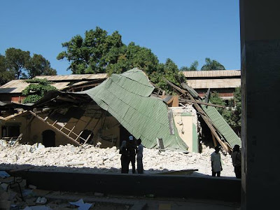 (9) Faculté des Sciences - ruines de l'ancien local - rue Mgr. Guilloux
 (8) Faculté des Sciences - ruines de l'ancien local - rue Mgr. Guilloux
***
 (9) Faculté des Sciences - ruines de l'ancien local - rue Mgr. Guilloux
***
Sources: ingénieurs Garry Jean et Claude Prépetit; metroplehaiti.com
vendredi 22 janvier 2010
Haïti-séisme/ Photos postées à MetropoleHaiti.com
Amies et amis internautes,
En cliquant sur le lien suivant, vous pourrez voir un à des centaines de photos des dégâts causés par le séisme du 12 janvier 2010: MetropoleHaiti.com.
En cliquant sur le lien suivant, vous pourrez voir un à des centaines de photos des dégâts causés par le séisme du 12 janvier 2010: MetropoleHaiti.com.
Haïti-séisme/Communiqué spécial de l'Ordre des Ingénieurs du Québec
Amies et amis internautes,
En tant que membre en règle, j'ai reçu de l'OIQ un communiqué spécial émis par sa présidente, Madame Maud Cohen, ing.
Prenez lecture du communiqué de l'OIQ en cliquant sur Haïti-séisme/OIQ.
Pierre Montès, Ph.D., ing.
En tant que membre en règle, j'ai reçu de l'OIQ un communiqué spécial émis par sa présidente, Madame Maud Cohen, ing.
Prenez lecture du communiqué de l'OIQ en cliquant sur Haïti-séisme/OIQ.
Pierre Montès, Ph.D., ing.
jeudi 21 janvier 2010
Aléa et risque sismique en Haïti
Par Claude Prépetit, ingénieur géologue
Conseiller Technique au Bureau des Mines et de l’Energie (BME)
Il s'agit d'un document de 5 pages en fichier pdf.
Il n'est pas daté. Selon les dates de certaines des références bibliographiques citées par l'auteur, on peut déduire que le document date de 2006 ou soit plus récent.
Pour le lire, cliquez sur Prepetit.
Le Coin de Pierre - Génie civil remercie l'ingénieur Lionel Duvalsaint de lui avoir communiqué ce lien.
Conseiller Technique au Bureau des Mines et de l’Energie (BME)
Il s'agit d'un document de 5 pages en fichier pdf.
Il n'est pas daté. Selon les dates de certaines des références bibliographiques citées par l'auteur, on peut déduire que le document date de 2006 ou soit plus récent.
Pour le lire, cliquez sur Prepetit.
Le Coin de Pierre - Génie civil remercie l'ingénieur Lionel Duvalsaint de lui avoir communiqué ce lien.
mercredi 20 janvier 2010
Haïti-séisme: Photos et vidéos du journal Le Nouvelliste
Amies et amis internautes,
Le lien suivant vous permettra d'accéder au site Web du journal Le Nouvelliste.
Vous pourrez alors y voir un grand nombre d'immeubles endommagés ou détruits, en photos et en vidéos.
Cliquez sur: Haïti-séisme/Le Nouvelliste.
Compliments au journaliste pour son travail.
Nous espérons que le journal rendra ce document disponible pour un temps illimité...
Le lien suivant vous permettra d'accéder au site Web du journal Le Nouvelliste.
Vous pourrez alors y voir un grand nombre d'immeubles endommagés ou détruits, en photos et en vidéos.
Cliquez sur: Haïti-séisme/Le Nouvelliste.
Compliments au journaliste pour son travail.
Nous espérons que le journal rendra ce document disponible pour un temps illimité...
lundi 18 janvier 2010
Haïti-séisme/ Jacmel en photos
*
 1.- Jacmel, photo: AFP/Andrew Bigosinski , 18 janvier 2010
***
 2.- Jacmel, photo Radio-Canada, 18 janvier 2010
***
Cliquez sur le lien suivant pour lire et/ou écouter un compte-rendu: Haïti-séisme/Jacmel.
dimanche 17 janvier 2010
«Port-au-Prince dévasté»
Amies et amis internautes,
Voici un lien vers un document mis en ligne par lefigaro.fr.
Vous pourrez visualiser un échantillon représentatif des dégâts à partir d'une carte interactive de la capitale d'Haïti qui ne l'est, maintenant, que sur papier:
Cliquez sur: Haïti-séisme/lefigaro.fr, 15 janvier 2010, 19:01.
Voici un lien vers un document mis en ligne par lefigaro.fr.
Vous pourrez visualiser un échantillon représentatif des dégâts à partir d'une carte interactive de la capitale d'Haïti qui ne l'est, maintenant, que sur papier:
Cliquez sur: Haïti-séisme/lefigaro.fr, 15 janvier 2010, 19:01.
vendredi 15 janvier 2010
Haiti-Earthquake/ Scientists warned Haitian officials in 2008 that the country was ripe for a major earthquake
*
 Haitians work at the collapsed St. Gerard Technical School.-
Photo: The Canadian Press, Jan, 15, 2010
Fri Jan 15, 5:21 AM
By Rick Callahan, The Associated Press
INDIANAPOLIS - Scientists who detected worrisome signs of growing stresses in the fault that unleashed this week's devastating earthquake in Haiti said Thursday they warned officials there two years ago that the country was ripe for a major earthquake.
Their sobering findings, presented during a geological conference in March 2008 and at meetings two months later, showed that the fault was capable of causing a 7.2-magnitude earthquake - slightly stronger than Tuesday's 7.0 quake that rocked the impoverished country.
Though Haitian officials listened intently to the research, the nearly two years between the presentation and the devastating quake was not enough time for Haiti to have done much to have prevented the massive destruction.
"It's too short of a timeframe to really do something, particularly for a country like Haiti, but even in a developed country it's very difficult to start very big operations in two years," said Eric Calais, a professor of geophysics at Purdue University.
Their conclusions also lacked a specific timeframe that could have prodded quick action to shore up the hospitals, schools and other buildings that collapsed and crumbled Tuesday, said Paul Mann, a senior research scientist at the University of Texas' Institute for Geophysics.
At the time of the earthquake, which the international Red Cross estimates killed 45,000 to 50,000 people, Haiti was still trying to recover from a string catastrophes. In 2008 alone, it was hit four times by tropical storms and hurricanes. The country also suffers from a string of social ills including poverty, unstable governments and poor building standards that make buildings vulnerable in earthquakes.
"Haiti's government has so many other problems that when you give sort of an unspecific prediction about an earthquake threat they just don't have the resources to deal with that sort of thing," Mann said.
In March 2008, Calais and Mann were among a group of scientists who presented findings on the major quake risk along the Enriquillo fault during the conference in the Dominican Republic, which shares the island of Hispaniola with Haiti. Their conclusions were based both on geologic work Mann conducted along the same fault and recent findings by Calais.
Calais had detected rising stresses along the fault using global positioning system measurements that showed that the Earth's crust in the area where the fault traverses southern Haiti was slowly deforming as pressure grew within the fault.
That pressure, paired with Mann's work and the fact that the last major quake in the area was in 1770, led to the prediction that the fault could produce a 7.2-magnitude temblor.
Calais said he also presented the findings to officials in Haiti during a series of meetings in May 2008 that included the country's prime minister and other high-ranking officials. He said he stressed to the officials that if they did nothing else they should at least begin reinforcing hospitals, schools and key government buildings to weather a strong quake.
"We were taken very seriously but unfortunately it didn't translate into action," he said. "The reality is that it was too short of a timeframe to really do something, particularly for a country like Haiti struggling with so many problems."
Calais said Haiti has no seismic stations for monitoring quake activity, while adjoining Dominican Republic has a small seismic network.
Although the specific risks of the fault zone near Haiti's capital, Port-au-Prince, may not have been known until recent years, the region has a long history of major earthquakes, said Carol Prentice, a U.S. Geological Survey research geologist based in Menlo Park, Calif.
Those include earthquakes that destroyed Jamaica's capital, Kingston, in 1692 and 1907, that also occurred along the Enriquillo fault, which extends hundreds of miles through the Dominican Republic, Haiti and Jamaica.
She said Calais' GPS studies were the first along the fault to quantify the potential quake risk in the heavily populated Port-au-Prince area.
Prentice said she, Calais and Mann had sought U.S. government funding over the years for detailed excavations in southern Haiti to document evidence of past quakes in soil layers along the fault but that work has not yet been funded.
"It's entirely possible that we'll see additional quakes along this fault in the years to come. But we really don't know the risk if those studies aren't done," she said.
______________________
This article comes from: Yahoo .
Please, read also: Phoenix Delacroix.
40.000 morts déjà enterrés à Haïti, 100.000 de plus redoutés
Source: Reuters, 15 janvier 2010
Par Catherine Bremer et Andrew Cawthorne
Par Catherine Bremer et Andrew Cawthorne
Les autorités haïtiennes ont déjà enterré 40.000 corps et pensent que 100.000 autres personnes ont perdu la vie dans le séisme qui a dévasté le pays mardi, a déclaré vendredi un responsable du gouvernement.
"Nous débarrassons les rues des cadavres et nous les mettons dans des fosses communes. Nous avons enterré 40.000 personnes. Nous pensons qu'il y en a 100.000 de plus", a déclaré à Reuters Aramick Louis, secrétaire d'Etat à la Sécurité publique.
"Il y a encore beaucoup de gens sous les décombres", a-t-il poursuivi.
"Il y a encore beaucoup de gens sous les décombres", a-t-il poursuivi.
....
... Le ministre de la Santé, Alex Larsen, a déclaré par ailleurs à Reuters que les trois-quarts de la capitale étaient à reconstruire après le tremblement de terre.
"Les trois-quarts de Port-au-Prince devront être reconstruits, pas seulement les quartiers totalement détruits, mais aussi les endroits où il y a énormément de maisons avec des dégâts structurels", a-t-il dit.
Interrogé sur les ressources dont dispose le gouvernement pour faire face à l'urgence sanitaire, le ministre a répondu: "Nous n'avons même pas une compresse (...) Nous attendons du matériel et des médicaments. Une partie est déjà arrivée et nous en sommes reconnaissants", a ajouté le ministre.
"Les trois-quarts de Port-au-Prince devront être reconstruits, pas seulement les quartiers totalement détruits, mais aussi les endroits où il y a énormément de maisons avec des dégâts structurels", a-t-il dit.
Interrogé sur les ressources dont dispose le gouvernement pour faire face à l'urgence sanitaire, le ministre a répondu: "Nous n'avons même pas une compresse (...) Nous attendons du matériel et des médicaments. Une partie est déjà arrivée et nous en sommes reconnaissants", a ajouté le ministre.
Pour lire l'article au complet, cliquez sur: REUTERS
Inscription à :
Articles (Atom)
